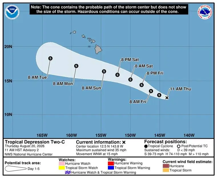
UPDATE: Flooding damage the biggest concern about incoming weather system
UPDATED 3:48 p.m.
A National Weather Service meteorologist said this afternoon the biggest concern about the second tropical cyclone potentially passing close to the Big Island in a week is flooding in already hard-hit areas.
Read more ‘Bows offensive lineman Ethan Spencer leading by exmaple
“Grounds in Hawaii are very porous. They drain very fast. But they’re still saturated. And with this rain, we could have more flooding damage, and that’s what we’re focused on,” John Bravender said about Tropical Depression Two-C during a press conference hosted by Gov. Josh Green in Honolulu.
The current NWS projection is that windward and southeast Hawaii Island could receive between 10 inches and 15 inches of rainfall between 6 a.m. Saturday and 6 a.m. Tuesday.
The cyclone will be given the name Tropical Storm Moke (pronounced Mow-kay) when maximum sustained winds are 40 mph. That could occur soon, because the storm is “expected to strengthen and move towards the islands in the next couple of days,” Bravender said.
“This is not the same as Lala. It looks like the track is going to be a little bit further south, and the wind field is not as large, so hopefully it won’t be as damaging. However, there could be a lot of rain with it … especially for southeastern sections of the Big Island, Ka‘u and Puna districts … ,” he added.
Bravender said that after Lala, “it’s an event to have another tropical cyclone form just like this.”
UPDATED 11 a.m.
Tropical Depression Two-C is about 900 miles east-southeast of Hilo, traveling to the west-northwest at 15 mph. The strength remains at maximum sustained winds of 35 mph, but is expected to strengthen gradually, according to the National Weather Service.
Read more ‘Take this new storm seriously’: A week after Lala, more potentially damaging weather is on the way
PREVIOUSLY
Tropical Depression Two-C has developed from a disturbance east-southeast of the Big Island and could develop into a tropical storm later today, according to forecasters.
At 5 a.m. today, Two-C was about 960 miles east-southeast of Hilo, with maximum sustained winds of 35 mph. It was moving to the west-northwest at 16 mph.
That direction in movement is expected for the next few days, according to the National Weather Service.
”On the forecast track, the center of the system is expected to pass near or south of the Big Island of Hawaii this weekend,” NWS forecasters said in a statement. “Gradual strengthening is forecast, and the depression could become a tropical storm later today.”
NWS forecasters said the Big Island could receive 5 to 10 inches of rainfall “with maximum amounts of 15 inches.”
“This rainfall may produce life-threatening flooding and mudslides, especially in steep terrain and over areas that were affected recently by Lala,” the forecasters said.
Read more Andre Ilagan is first from UH to be invited to play in U.S. Open

Related Posts

Remembering Hawaii’s 9/11 victims

World Manta Day returns today
