Strengthening El Nino could add fuel to Hawaii’s hurricane season
This year’s El Nino cycle strengthened and could become one of the strongest on record, adding more fuel to one of Hawaii’s most devastating hurricane seasons.
Read more Trump approves major disaster aid for Hawaii after Lala, Lowell
Sea surface temperatures were more than 4 degrees Celsius above average in parts of the eastern equatorial Pacific, the latest forecast from the National Oceanic and Atmospheric Administration’s Climate Prediction Center said, and it’s only expected to get warmer through the end of the year.
NOAA El Nino Southern Oscillation team lead and physical scientist Michelle L’Heureux told the Honolulu Star-Advertiser a historic event would mean average equatorial sea-surface temperatures would exceed 2.5 degrees Celsius above normal for a three-month period. For the most recent three-month period, July through September, temperatures were 1.7 degrees Celsius above normal.
The chances of a historic event, or temperatures exceeding 2.5 degrees Celsius above normal, is 54% for September through November, 83% for October through December and 70% for November through January.
Hawaii’s hurricane season typically runs from June through November.
One of the strongest El Ninos on records occurred from 1982 through 1983, where sea-surface temperatures measured 2.4 degrees Celsius above normal from November through January and from December through February. That year saw the late-season Hurricane Iwa, which passed just 25 miles west of Kauai’s Napali Coast on Nov. 23, 1982. The storm wreaked havoc on Kauai, Oahu and Niihau, causing one death and $250 million in damage, not adjusted for inflation.
Dan Harnos, a meteorologist with the National Weather Service’s Extended Prediction Division, said Hawaii’s hurricane season is still expected to wind down in November, but noted that there is “limited precedent” for El Nino conditions to extend the season into early December.
For example, he said, Category 1 storm Hurricane Nina formed south of the islands on Nov. 29, 1957, and moved toward Kauai through Dec. 2, when it turned west. Despite being 120 miles away from Kauai, it dumped more than 20 inches of rain on Wainiha in 14 hours, produced 35-foot surf and generated 92 mph winds on the island. The storm caused $100,000 in damage not adjusted for inflation, destroyed 12 homes and caused four deaths. It’s the only known cyclone to impact Hawaii in December.
According to historical NOAA data, sea-surface temperatures were 1.5 degrees Celsius above normal from October through December and 1.8 degrees above normal — a “strong” El Nino cycle — from November through January during that year.
But, Harnos emphasized, “strong” or “very strong” El Nino cycles do not mean more severe storms are for certain. It just means it may be more likely for them to occur.
Read more $1M bail maintained for Puna woman, 54, accused of trying to kill estranged husband
“El Nino is only one factor in the upcoming seasons and can influence the chances of a certain outcome,” Harnos explained. “Much like weighted dice where a certain number may be rolled more often at the expense of other numbers, you can still end up with any number on your roll.”
There are also plenty of other “very strong” El Nino cycles where hurricanes did not come close to Hawaii.
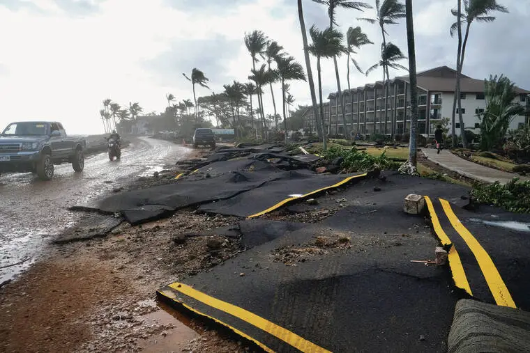
Forecasters still predict the Central Pacific Basin could see seven to 13 named storms. So far, there have been six named storms — five of which were hurricanes and three of which were major hurricanes. Hurricane Lala in August and Hurricane Lowell in September were particularly devastating for the Big Island and Kauai, respectively. The two storms caused around $220.4 million in damage, destroyed 39 homes, caused major damage to 149 homes and killed at least five residents.
The El Nino cycle is likely to remain “very strong” through the three-month period ending in February, with it potentially weakening from January through April. Beginning in April, it becomes more likely the cycle will be in “neutral” conditions, meaning sea-surface temperatures are normal and will have little impact on global weather patterns.
But impacts from the previous strong conditions could still be devastating — even in neutral conditions, Hawaii State Climatologist Pao-Shin Chu said. Both he and Harnos predict winter, which is usually Hawaii’s wet season, will be particularly dry.
“In Hawaii, we become very dry after the onset of a strong El Nino,” Chu said.
The busy hurricane season causing abnormal rainfall this past summer and fall has helped vegetation flourish, Chu explained, and when that vegetation dries out from a more arid than usual winter through spring, it could add fuel to wildfires in the summer and fall.
He added that the dry winter also could impact livestock ranchers and agriculture.
“Even though hurricane season is about to be over,” Chu said, “it also can bring other kinds of problems.”
Read more Hilo judge overrules planning commission, grants permit for Keaukaha apartment complex