Researchers deploy sensors in aftermath of 6.0 quake
Following the magnitude-6.0 earthquake that rocked Hawaii Island on May 22, researchers from the University of Hawaii have been at work trying to better understand the cause and implications of the event, which damaged about 150 structures.
Following the magnitude-6.0 earthquake that rocked Hawaii Island on May 22, researchers from the University of Hawaii have been at work trying to better understand the cause and implications of the event, which damaged about 150 structures.
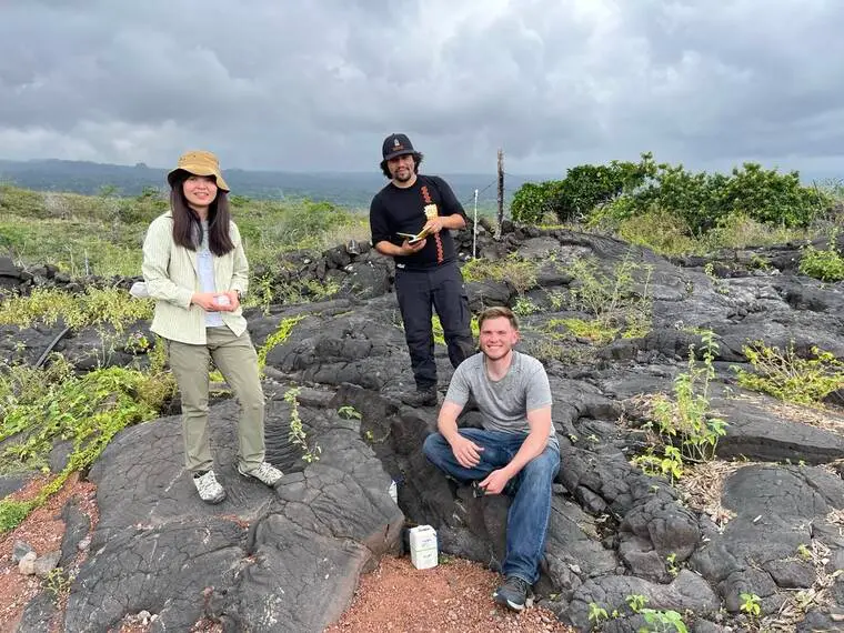
Sin-Mei Wu, a seismologist at UH Manoa, was at the site of the earthquake’s epicenter – about 7 miles south of Honaunau-Napo‘opo‘o on the Kona side – last week with a team of researchers to deploy an array of seismic sensors.
While the U.S. Geological Survey’s Hawaiian Volcano Observatory maintains a network of sensors across the island, Wu said they are primarily concentrated in areas of high volcanic activity, and there were very few near the Honaunau area.
She and her team set up a total of 30 temporary, portable sensors at 15 different locations around Pu‘uhonua o Honaunau National Historic Park to capture and observe potential aftershocks.
“That is our goal. We want to capture all of the aftershocks, and then try to characterize them,” she said, adding that they detected a 3.3-magnitude quake in the same area on Monday. “It does not give the same shaking, but is actually coming from the same source area as the magnitude six, so studying this type of smaller earthquake can also help us to understand what’s going on.”
Unlike the more frequent, lower-magnitude volcano-related quakes on the island, the May 22 event was what is known as a flexure earthquake, meaning it was caused by the tectonic plate on which Hawaii sits bending, 14 miles below sea level, due to the weight of the islands on top of it, according to USGS.
Helen Janiszewski, another UH Manoa seismologist who works with Wu, said that Hawaii’s location in relation to tectonic plates make it unique compared to many other seismically active regions.
“One of the key things here is, Hawaii, we’re in the middle of a tectonic plate, not at a plate boundary. Most earthquakes happen at plate boundaries along well-defined fault zones,” she said. “We have a very different system here.”
Because of this, she said studying events like the recent quake can be more challenging without similar settings with which to compare.
“Unlike other tectonic boundaries, it’s very hard for us to infer what sorts of processes govern these types of flexure earthquakes in detail, because we can’t infer from analogous systems elsewhere globally quite as easily,” she said. “At plate boundaries, there are analogous systems for comparison, and so this is why it’s particularly important that we were able to deploy this temporary array to study this aftershock sequence, because it’ll help us to better understand the fault geometry.”
The array of sensors will remain in place for two months, which Wu said should be long enough to capture any additional aftershocks.
Janiszewski said it also provides a window to gather data that will provide researchers valuable insight into seismic activity in this region of West Hawaii.
“Since this is a kind of gap in the permanent network maintained by HVO, it also just represents an opportunity to get some first-ever, high-resolution, dense seismic data in an area of the Hawaiian Islands that hasn’t been studied as much,” she said. “The response to the earthquake is obviously the primary driver here, but we’ll definitely also be looking for more general kinds of structural information for an understudied area.”
Thomas Lee, a geology professor at UH Hilo, has also been involved in the project and helped coordinate the deployment of the sensors.
He said he hopes the data collected will improve understanding of earthquakes in the islands and help communities better prepare for them.
“We can’t predict earthquakes. We can’t tell you, ‘well, there’s going to be a magnitude five and a half in three months from now,’ but we do our best to forecast them, which is to say that here’s the percent chance that you’re going to experience this amount of shaking in this place in the next 20 years,” he said.
“The better the information we have, the better we can make things like our building codes and our preparations that go into things as varied as the Civil Defense warnings, to letting the emergency managers and the fire department and all these other stakeholders know what should be expected.”
Read more NOAA declares El Nino as forecasters warn of extreme weather
Email Grace Inez Adams at [email protected].