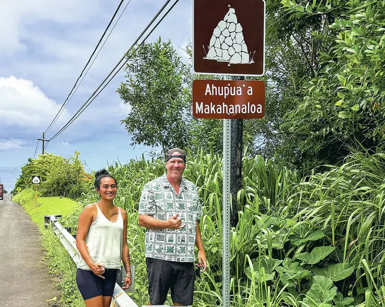
Community group hopes efforts to install signs designating ahupua‘a will catch on
A community-led effort is underway to recognize and mark the traditional ahupua‘a land divisions of Hawaii Island.
Read more Framber Valdez fires 7 scoreless innings as Tigers thump Mariners
A community-led effort is underway to recognize and mark the traditional ahupua‘a land divisions of Hawaii Island.
Typically stretching from the mountains to the sea, Native Hawaiians designed ahupua‘a to organize the land in a way that ensured communities living within each one had access to all the land- and water-based resources needed to live sustainably.
Following a push from Pepe‘ekeo-based nonprofit Makahanaloa Fishing Association, the state Department of Transportation has developed a new application process for Hawaii Island communities to be able to request signs be installed along state highways acknowledging historic ahupua‘a boundaries.
The fishing association has successfully applied for nearly a dozen signs to be installed marking ahupua‘a throughout the Hilo Paliku area over the past year, including Makahanaloa, for which the group is named.
“I always get excited when I pass the signs,” MFA Coordinator Wai Wichimai said. “I say the names of that place, and I feel like it breathes a little bit more life into that ‘aina and the history of that place, as well.”
She said she hopes the signs catch people’s attention as they drive by and inspire them to reflect and want to learn more.
“These are storied areas, and they’re not just plots of land that you’re passing through,” she said. “I feel like it makes you think a little bit more about where you are and what has been there before you and who has been there before you, and the connections that those people have to those areas.”
On Hawaii Island, there are over 500 ahupua‘a — more than any other island — which Wichimai said she thinks is part of the reason signs had not previously been installed like they have elsewhere.
However, several years ago when the DOT expanded the Queen Ka‘ahumanu Highway in Kona, several ahupua‘a signs were installed as part of a cultural preservation agreement. MFA President Blake McNaughton noticed them.
“That was the only place on the island that we saw them, but we were like, oh, okay, it’s possible to get these signs, but how come nobody else has them?” McNaughton said.
He said it inspired him and Wichimai to look into the process of requesting more signs. They reached out to the DOT and started working with DOT Hilo-based engineer Kaikea Kalipi to build on an existing ahupua‘a signage program on Oahu to develop an application specifically for Hawaii Island communities to request signs.
“Hawaii Island is unique in that we have a lot of ahupua‘a compared to other islands, and our ahupua‘a are quite narrow, so it’s a lot of signs,” said Kalipi. “But a lot of it was community driven, and I think … what really allowed the program to continue to move forward was the push from the community.”
Kalipi is no longer with the DOT, but said he hopes the work he did with the MFA to formalize and streamline the application process makes it possible for the program to continue.
Read more New MLS commissioner: ‘There’s so much upside’
“As a kanaka myself, I think that marking our places and having our places being known and out there is an important part of the lahui’s identity and knowing where you are,” he said.
While the ahu, piles of stones that once marked the edges of ahupua‘a — and inspired the design on the signs – have largely been lost, knowledge of where the boundaries once lay has been passed down over the years.
“The sugar industry bulldozed pretty much the blueprint of how kanaka had been living in this area for thousands of years sustainably … ,” said MFA President McNaughton. “(But) there’s still clues for us in the valleys, there’s still clues for us on the shoreline, and there’s still clues for us in the names of our places and our streams.”
He said communities have drawn on these clues and the insight of kupuna and other community members to identify where signs should be placed. The state also has an online GIS map showing ahupua‘a boundaries, but McNaughton said they are not always in alignment with where local residents believe them to be located.
With this in mind, the DOT created two applications people can fill out to request signs. If they agree with the boundaries on the state’s map, it is a simplified process that requires no additional research. If they disagree, there is an option to submit evidence to support putting the sign where they think the boundary should be.
McNaughton said the MFA successfully requested several signs be placed at locations differing from the map. The organization also recently held a community information session to walk others through the process of applying for signs in their communities.
“We feel like we, because we have members that span most of Hilo Paliku, from Wailuku to O‘okala, that we can help to continue that effort,” he said. “But it’s not our place to go and put signs up in other communities, and so, yeah, we’re just hoping somebody takes on that passion.”
From submitting an application to getting a sign installed, the process takes approximately six months. While it may take some time, Wichimai said she and McNaughton hope to someday see the signs islandwide.
“We would both like to see these signs around the whole island,” she said. “That would be amazing.”
Beyond recognizing the history of the island, McNaughton said he also hopes increased signage could lead to a mindset shift in how people view and interact with the land.
“When we see those names every day, and we think about like, ‘hmmm, I wonder, what is that telling us about how we should manage this area? Or have a relationship with this area?’ I think that’s super powerful,” he said.
More information about the ahupua‘a signage application process can be found at tinyurl.com/3z98rrcr.
Read more How Mariners fit 50 seasons into biggest celebration in their history
Email Grace Inez Adams at [email protected].

Related Posts
Lowell leaves Port Allen devastated as boat operators consider next move

Remembering Hawaii’s 9/11 victims
