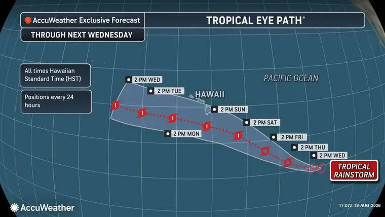
Another storm is brewing southeast of the Big Isle
As the Big Island continues to reel from the devastation wrought over the weekend by Hurricane Lala, another potential threat looms to the southeast of Hawaii.
Read more MLB roundup: Brewers match club record with 22 runs, blank Mariners
Dubbed EP90 by the National Hurricane Center in Miami, the tropical rainstorm — on the verge of crossing from the Eastern Pacific into the Central Pacific — is producing showers and thundershowers and is showing signs of organizing into a tropical cyclone.
“Environmental conditions appear favorable for further development of this system, and a tropical depression is likely to form during the next day or so as the system moves westward to west-northwestward at 10 to 15 mph and crosses into the Central Pacific. Interests in the Hawaiian Islands should closely monitor the progress of this system,” wrote NHC forecaster Larry Kelly in an update today.
The probability that the low-pressure system will form into a cyclone within the next 48 hours is 90%, according to Kelly.
Read more Lawmakers assess Lala damage; $6M in emergency funds OK’d
AccuWeather forecasters say the current track based on computer forecast models could have the storm passing within 100 miles south of Hawaii Island as a hurricane either Sunday or Sunday night — just a week after Hurricane Lala passed 30 miles south of the island, causing significant damage and apparently at least two deaths.
“The Big Island will be especially sensitive to flooding after Lala already caused significant flooding and mudslides last weekend,” said AccuWeather lead hurricane expert Alex DaSilva. “The rainfall amounts and location of the rain is going to be largely dependent on the storm track, which could move farther south and largely miss the islands.
“That doesn’t mean there wouldn’t be significant impacts to land, though.”
Widespread rainfall amounts of 4-8 inches are expected across the island, with a potential for 24 inches in some areas. Flooding and gusty winds could occur, forecasters say, with the highest risk for impacts to lives and property expected to be across the higher elevations and windward side of the island.
Read more Mariners show resolve day after historic loss with bounce-back win
Email John Burnett at [email protected].

Related Posts

Remembering Hawaii’s 9/11 victims

World Manta Day returns today
