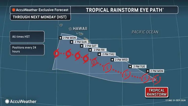
Tropical disturbance expected to bring heavy rain, potential flooding later in week
In what’s become almost a weekly occurrence, Big Islanders are once again being advised to batten down the hatches, as a tropical rainstorm is forecast to bring heavy rain and perhaps thundershowers with potential flooding.
Read more Rainbow Wahine storm back to beat Iowa State
The remnants of the former Tropical Depression 15-E are about 800 miles southeast of Hawaii Island. According to the National Weather Service’s extended forecast, the storm is expected to bring multiple days of heavy rain starting Wednesday evening on the Hilo side and by Friday evening on the Kona side.
As a precaution, residents of Hawaii Island are being asked asked by Hawaii County Civil Defense to remain vigilant and to take this time to develop your personal, family and business emergency preparedness plans for possible heavy rain and windy conditions.
“Although it’s a little early in the forecast, we could see some rainfall, maybe some wind, but right now, the rainfall seems to be the most concerning element of that system coming through …,” Darryl Oliveira, the county’s acting Civil Defense administrator, told the Tribune-Herald today. “We could see in some areas between 3 to 4 inches and in the same area, it could go as high as in excess of 7 to 10 inches.
“We’re watching it, especially for those flood-prone areas down southeast.”
The areas he’s referring to — Pahala, Naalehu and Waiohinu — were damaged heavily by Hurricane Lala as the storm passed closely to the south in August. Several storms have approached Hawaii since, with forecasters warning of potential additional flood damage in those communities because the ground there was already saturated.
Oliveira said those communities haven’t seen additional damage from mudslides and the like, but more recent rainfall has caused Highway 11 and other roads in Ka‘u to be closed due to flooding.
“Last week, we were watching one event, and then the week prior on a Wednesday, when we had our community meeting, we saw the highway get closed that night, as well as some runoff in Naalehu and Waiohinu,” he said. “So we’re watching all of these, especially those that may occur at times when the students are in school and how it affects transportation, with them getting back home, etc.”’
Forecasters predict a 90% chance the remnants of 15-E will regain tropical depression strength or become a tropical storm within a week. If it attains tropical storm status, the storm will be named Nolo.
AccuWeather said the storm was about 800 miles southeast of the Big Island on Monday and is forecast to track west to northwest this week.
Read more Puna man accused of assaulting two police officers
“The biggest concern with this storm is how slowly it could move once it approaches Hawaii,” said AccuWeather meteorologist Peyton Simmers. “The storm could slow dramatically or even stall south of the islands, funneling tropical moisture over the same areas for an extended period of time. That could turn this into a prolonged rainfall event lasting into the weekend.
“If it stalls close enough to the Big Island, rainfall totals could become extreme and the flooding threat would increase significantly.”
AccuWeather forecast between 4 to 8 inches of rain, with 8 to 12 inches possible along eastern slopes on the Big Island, although even heavier totals could be seen. One computer model predicts a possibility of 24 inches of rainfall.
“The storm’s exact track and speed remain critical,” the forecast service said in a report. “Even a relatively small shift could dramatically change how much rain falls across Hawaii. A track closer to the Big Island would increase the potential for significant rainfall and flooding, while a track farther south could result in much lower rainfall totals across the island.”
In an extraordinarily busy hurricane season, two named storms are churning in the Eastern Pacific, with both still too far away to present a current threat to Hawaii.
The closer of the two, Tropical Storm Odalys, remains well east of the Central Pacific basin. Odalys is expected to strengthen into a hurricane either Tuesday or Wednesday.
And off the coast of southwestern Mexico, Hurricane Polo is expected to intensify from a category-1 cyclone to a major hurricane on Tuesday or Wednesday. It is forecast to turn to the northwest or west-northwest and track northward along the Mexican shoreline.
Read more Wahine so close, but fall to Bruins in 5-set Lucky Aces Invitational battle
Email John Burnett at [email protected].

Related Posts

Cats found shot to death on Banyan Drive

Police ID victim in fatal rollover in Puna