Tropical Storm Elida is expected to become the Pacific’s first hurricane of 2026
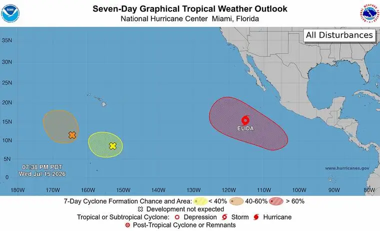
National Weather Service forecasters are keeping tabs on a tropical storm in the Eastern Pacific and two disturbances in the Central Pacific.
Read more Life as a Super Bowl-winning coach is good for the Seahawks’ Mike Macdonald
National Weather Service forecasters are keeping tabs on a tropical storm in the Eastern Pacific and two disturbances in the Central Pacific.
Tropical Storm Elida was less than 600 miles south-southwest of the southern tip of Mexico’s Baja California peninsula late Wednesday afternoon. It’s the fifth named storm of the 2026 hurricane season, following Tropical Storms Amanda, Boris, Cristina and Douglas.
None of those storms crossed from the Eastern Pacific into the Central Pacific.
Elida, which formed Tuesday, was packing maximum sustained winds of 50 mph and moving to the west at 14 mph. Tropical-storm-force winds extend about 105 miles from the storm’s center.
The storm is expected to take a gradual turn to the west-northwest and northwest over the next few days, and Elida is expected to become the Pacific’s first hurricane of the 2026 season on Friday.
Laura Farris, a National Weather Service Honolulu forecaster, said that neither Elida nor the two disturbances in the Central Pacific — Disturbance 1 to the south-southwest of the islands and Disturbance 2 to the south-southeast — appear at this time to present a threat to make landfall in the islands.
Read more Police: Body found at Kona beach park
“We look at the National Hurricane Center products, and we’re also looking at the (computer-generated) models in a long range to see what may happen in that time period,” Farris replied when asked what forecasters are doing to monitor the situation. “And we look at the overall conditions across the Pacific to see if they become more favorable to tropical cyclones.”
As of late Wednesday afternoon, Disturbance 1 was moving slowly northwestward toward Johnston Atoll, some 825 miles southwest of Hawaii. Described as a broad area of low pressure with disorganized showers and thunderstorms, forecasters are predicting a 50% chance of its formation into a tropical depression by Friday.
Disturbance 2, described as a broad area of low pressure producing limited showers and thunderstorm activity, is being given only a 10% chance by forecasters of developing into tropical depression in the next week.
With a strengthening El Nino — a weather phenomenon caused by warmer than normal equatorial waters in the Pacific — forecasters have predicted an unusually robust hurricane season with five to 13 tropical cyclones.
“With this being an El Nino year, I’d say that if you haven’t prepared for the (hurricane) season, now is the time,” Farris said.
Read more Lava fountaining returns to Kilauea’s Halemaʻumaʻu crater
Email John Burnett at [email protected].

Related Posts

Remembering Hawaii’s 9/11 victims

World Manta Day returns today
